Close Menu
    Facebook X (Twitter) Instagram
    SciTechDaily
    • Biology
    • Chemistry
    • Earth
    • Health
    • Physics
    • Science
    • Space
    • Technology
    Facebook X (Twitter) Pinterest YouTube RSS
    SciTechDaily
    Home»Earth»Revolutionary GPS Method Reveals Earth’s Crust Movements Post-Earthquake
    Earth

    Revolutionary GPS Method Reveals Earth’s Crust Movements Post-Earthquake

    By Chinese Academy of SciencesAugust 6, 2024No Comments3 Mins Read
    Facebook Twitter Pinterest Telegram LinkedIn Tumblr WhatsApp Email
    Share
    Facebook Twitter LinkedIn Pinterest Telegram Email
    GPS Earthquake Art
    Researchers employed sub-daily GPS data to precisely measure early afterslip after the 2010 Maule earthquake, improving seismic hazard predictions and emergency response strategies. Credit: SciTechDaily.com

    A groundbreaking study using sub-daily GPS has improved our understanding of early afterslip following earthquakes, offering a more accurate assessment of seismic hazards and enhancing emergency response and preparedness strategies.

    A groundbreaking study has revealed new insights into the Earth’s crust’s immediate behavior following earthquakes. Researchers have utilized sub-daily Global Positioning System (GPS) solutions to accurately measure the spatial and temporal evolution of early afterslip following the 2010 Mw 8.8 Maule earthquake. This innovative approach marks a significant advancement in seismic analysis, offering a more precise and rapid depiction of ground deformations, which is essential for assessing seismic hazards and understanding fault line activities.

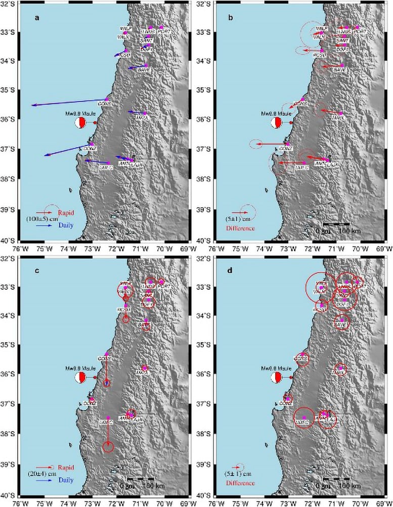
    The aftermath of an earthquake is marked by intricate postseismic adjustments, particularly the elusive early afterslip. Daily seismic monitoring has struggled to capture the rapid and complex ground movements occurring in the critical hours post-quake. The intricacies of these initial activities and their profound implications for seismic hazard assessment highlight an urgent need for more refined and immediate monitoring techniques.

    Postseismic Deformation Patterns of the 2010 Mw 8.8 Maule Earthquake
    Postseismic Deformation Patterns of the 2010 Mw 8.8 Maule Earthquake. a Horizontal and c vertical components of coseismic displacement calculated by rapid (10 min) and daily (24 h) solution, and their difference for b horizontal and d vertical components. The red and blue arrows indicate sub-daily (rapid) and daily solutions, respectively. Credit: Satellite Navigation

    Innovations in Seismic Data Analysis

    Wuhan University researchers, in a paper published on July 29, 2024, in Satellite Navigation, unveil their meticulous examination of the Maule earthquake’s early afterslip. Utilizing sub-daily GPS solutions, the study delivers a comprehensive narrative of the ground surface deformations occurring in the pivotal hours following the earthquake.

    This study employs sub-daily GPS data to provide a high-resolution depiction of the 2010 Mw 8.8 Maule earthquake’s postseismic afterslip. The innovative approach captures the rapid ground deformations that typically elude daily GPS measurements, revealing a nearly 10% reduction in the overestimation of coseismic displacements. The research illustrates the predominance of afterslip in the first 36 hours, overshadowing poroelastic effects, and contributes significantly to seismic hazard assessment. The findings enhance the clarity and depth of our understanding of the Earth’s postseismic dynamics, offering a robust tool for improving early warning systems and disaster response strategies.

    Dr. Yangmao Wen, the study’s corresponding author, highlights its significance, noting, “Our research demonstrates the sub-daily GPS’s adeptness at capturing the intricate dynamics of early afterslip, which is crucial for evaluating seismic risks and deciphering fault behavior post-earthquakes.”

    The deployment of sub-daily GPS in seismic studies heralds a new era in hazard management. It enables a more accurate and expedited assessment of postseismic activities, allowing for more effective responses to earthquake impacts. The enhanced accuracy in early afterslip measurements is set to improve aftershock predictions, optimize emergency preparedness, and mitigate the seismic vulnerability of at-risk communities. This advancement in geodetic monitoring is a step change toward a more profound comprehension of earthquake dynamics and their societal implications.

    Reference: “Rapid early afterslip characteristics of the 2010 moment magnitude (Mw) 8.8 Maule earthquake determined with sub-daily GPS solutions” by Kai Liu, Yangmao Wen, Jing Zeng, Jianghui Geng, Zhao Li and Caijun Xu, 29 July 2024, Satellite Navigation.
    DOI: 10.1186/s43020-024-00145-6

    This work is funded by the National Natural Science Foundation of China (42025401 and 42374003), and the Hubei Luojia Laboratory (No. 220100021).

    Chinese Academy of Sciences Earthquakes GPS Seismology
    Share. Facebook Twitter Pinterest LinkedIn Tumblr Email

    Related Posts

    Predicting Earthquakes: Slight Shifts in Magnetic Field Preceded California Quakes

    A Global Tsunami: How Did the Tonga Tsunami Jump From Ocean to Ocean?

    Changes in Earth’s Outer Core Revealed by Seismic Waves From Earthquakes

    Diamonds That Formed Deep in the Earth Could Help Explain Earthquake Mystery

    Quake-Ception – Groundbreaking Earthquake Discovery: Risk Models Overlook an Important Element

    Resolving a Dangerous Conundrum: Earthquake Depth Impacts Potential Tsunami Threat

    A New Method to Preventing Human-Induced Earthquakes Caused by the Oil and Gas Industry

    Fracking Wastewater Injection Wells Linked to Earthquakes

    Analysis of 2011 Virginia Earthquake Suggests Seismic Risk

    Leave A Reply Cancel Reply

    • Facebook
    • Twitter
    • Pinterest
    • YouTube

    Don't Miss a Discovery

    Subscribe for the Latest in Science & Tech!

    Trending News

    Could Perseverance’s Mars Samples Hold the Secret to Ancient Life?

    Giant Fossil Discovery in Namibia Challenges Long-Held Evolutionary Theories

    Is There Anybody Out There? The Hunt for Life in Cosmic Oceans

    Paleontological Surprise: New Research Indicates That T. rex Was Much Larger Than Previously Thought

    Photosynthesis-Free: Scientists Discover Remarkable Plant That Steals Nutrients To Survive

    A Waste of Money: New Study Reveals That CBD Is Ineffective for Pain Relief

    Two Mile Long X-Ray Laser Opens New Windows Into a Mysterious State of Matter

    650 Feet High: The Megatsunami That Rocked Greenland’s East Coast

    Follow SciTechDaily
    • Facebook
    • Twitter
    • YouTube
    • Pinterest
    • Newsletter
    • RSS
    SciTech News
    • Biology News
    • Chemistry News
    • Earth News
    • Health News
    • Physics News
    • Science News
    • Space News
    • Technology News
    Recent Posts
    • Mystery Solved: Scientists Discover Unique Evolutionary Branch of Snakes
    • Unlocking the Deep Past: New Study Maps the Dawn of Animal Life
    • Scientists Uncover How Cocaine Tricks the Brain Into Feeling Good – Breakthrough Could Lead to New Substance Abuse Treatments
    • Scientists Sound the Alarm: Record Ocean Heat Puts the Great Barrier Reef in Danger
    • New Study Unravels the Mystery of COVID’s Worst Pediatric Complication
    Copyright © 1998 - 2024 SciTechDaily. All Rights Reserved.
    • Latest News
    • Trending News
    • Privacy Policy
    • Terms of Use

    Type above and press Enter to search. Press Esc to cancel.