Close Menu
    Facebook X (Twitter) Instagram
    SciTechDaily
    • Biology
    • Chemistry
    • Earth
    • Health
    • Physics
    • Science
    • Space
    • Technology
    Facebook X (Twitter) Pinterest YouTube RSS
    SciTechDaily
    Home»Earth»Hidden Wonders: A Piece of Rhode Island in the Atlantic
    Earth

    Hidden Wonders: A Piece of Rhode Island in the Atlantic

    By Adam Voiland, NASA Earth ObservatoryAugust 3, 2024No Comments3 Mins Read
    Facebook Twitter Pinterest Telegram LinkedIn Tumblr WhatsApp Email
    Share
    Facebook Twitter LinkedIn Pinterest Telegram Email
    Block Island
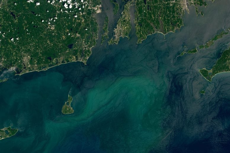
    Block Island and the southern mainland of Rhode Island captured on July 3, 2024, by the Operational Land Imager on Landsat 8.

    Block Island, shaped by glacial movements, hosts significant natural and human-made features including popular harbors and an offshore wind farm.

    The conservation efforts on the island help protect numerous species, including the threatened American burying beetle.

    Formation and Geography of Southern New England Islands

    Roughly 20,000 years ago, the Laurentide Ice Sheet smothered what is now southern New England beneath a thick layer of ice. The leading edge of this hulking mass plowed into the landscape as it advanced, depositing piles of debris called terminal moraines at its southernmost extent. These piles of glacial till became the foundation for the archipelago of islands that now flank southern New England: Long Island, Nantucket, Martha’s Vineyard, and Block Island.
    Block Island Annotated
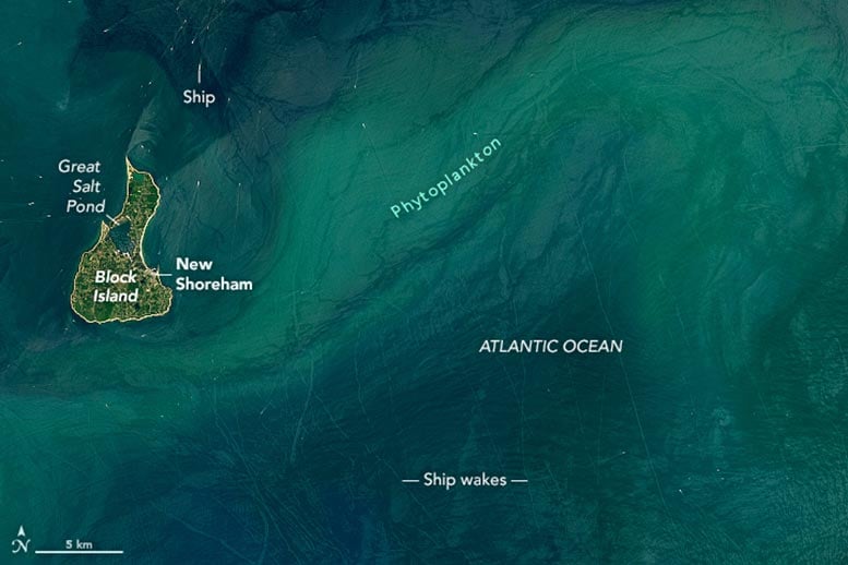
    Block Island captured on July 3, 2024, by the Operational Land Imager on Landsat 8.

    Observing Block Island Today

    Block Island is visible in these images, acquired on July 3, 2024, by the OLI (Operational Land Imager) on Landsat 8. The pear-shaped island, located about 9 miles (14 kilometers) south of mainland Rhode Island, is about 6 miles long and 3.5 miles wide. Roughly 1,400 people live on Block Island, mostly in the town of New Shoreham. A combination of sunglint and a phytoplankton bloom made the wakes trailing behind the many boats near the island especially visible at the time of this image.

    Evolution of Great Salt Pond

    Great Salt Pond, once a freshwater pond, became tidal in 1905 when the U.S. Army Corps of Engineers dug a 0.6-mile-long channel to the ocean. The channel helped turn Great Salt Pond (also called New Harbor) into one of the most popular harbors in the Northeast, attracting about 1,500 boats to its three marinas on any given day in the summer. The smaller Old Harbor on the east side of the island is protected by a breakwater and serves as the main entry point for ferries arriving from Rhode Island, Connecticut, Massachusetts, and New York. The harbor also contains slips for commercial and charter fishing boats.
    Block Island Wind Turbines
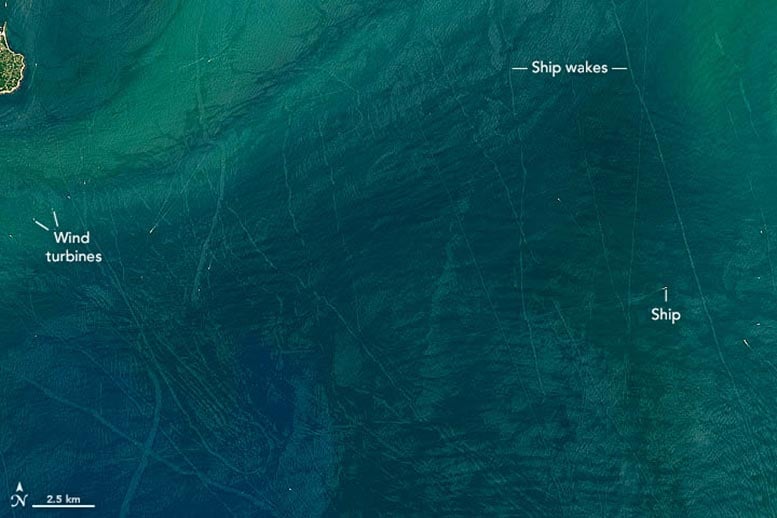
    Wind turbines and ship wakes off the southern mainland of Rhode Island captured on July 3, 2024, by the Operational Land Imager on Landsat 8.

    Renewable Energy and Conservation on Block Island

    Five wind turbines form a line several miles southeast of Block Island. The turbines, installed in 2016 as part of the first offshore wind farm in the United States, replaced five diesel generators. Now, just 10 percent of the electricity they generate powers all of Block Island. The rest is exported to the mainland.

    Conservation areas span about 40 percent of the island, including much of the land north of Great Salt Pond. The Block Island National Wildlife Refuge is one such area and hosts more than 70 species of migratory songbirds, as well as the largest colony of gulls in Rhode Island. The refuge also provides habitat for the American burying beetle, a large black-and-orange beetle that feeds on carrion. When the beetle was listed as endangered in 1989, the community on Block Island was just one of two populations known to remain in the United States. The beetles were recategorized as threatened in 2020.

    NASA Earth Observatory images by Lauren Dauphin, using Landsat data from the U.S. Geological Survey.

    Geography NASA NASA Earth Observatory Popular
    Share. Facebook Twitter Pinterest LinkedIn Tumblr Email

    Related Posts

    From Russia With Questions: Distinctive Striping Pattern in Siberia Puzzles Researchers

    A Geologist’s Dream: A Short Journey to the Center of the Earth

    Spied by Satellite: Phytoplankton Factory in the Argentine Sea

    Elephant Island: The Incredible Survival Story of Ernest Shackleton and the Crew of HMS Endurance

    Robinson Crusoe Island Captured by Landsat 8 Satellite

    Huacachina: The Only Natural Oasis in South America

    NASA Picturing Earth: Astronaut Photography In Focus [Video]

    NASA Scientists Map Beirut Blast Damage – Devastating Explosion Rocked Port Area

    NASA Advanced Rapid Imaging Satellite Maps Blast Damage: Beirut Explosion Aftermath

    Leave A Reply Cancel Reply

    • Facebook
    • Twitter
    • Pinterest
    • YouTube

    Don't Miss a Discovery

    Subscribe for the Latest in Science & Tech!

    Trending News

    Could Perseverance’s Mars Samples Hold the Secret to Ancient Life?

    Giant Fossil Discovery in Namibia Challenges Long-Held Evolutionary Theories

    Is There Anybody Out There? The Hunt for Life in Cosmic Oceans

    Paleontological Surprise: New Research Indicates That T. rex Was Much Larger Than Previously Thought

    Photosynthesis-Free: Scientists Discover Remarkable Plant That Steals Nutrients To Survive

    A Waste of Money: New Study Reveals That CBD Is Ineffective for Pain Relief

    Two Mile Long X-Ray Laser Opens New Windows Into a Mysterious State of Matter

    650 Feet High: The Megatsunami That Rocked Greenland’s East Coast

    Follow SciTechDaily
    • Facebook
    • Twitter
    • YouTube
    • Pinterest
    • Newsletter
    • RSS
    SciTech News
    • Biology News
    • Chemistry News
    • Earth News
    • Health News
    • Physics News
    • Science News
    • Space News
    • Technology News
    Recent Posts
    • Mystery Solved: Scientists Discover Unique Evolutionary Branch of Snakes
    • Unlocking the Deep Past: New Study Maps the Dawn of Animal Life
    • Scientists Uncover How Cocaine Tricks the Brain Into Feeling Good – Breakthrough Could Lead to New Substance Abuse Treatments
    • Scientists Sound the Alarm: Record Ocean Heat Puts the Great Barrier Reef in Danger
    • New Study Unravels the Mystery of COVID’s Worst Pediatric Complication
    Copyright © 1998 - 2024 SciTechDaily. All Rights Reserved.
    • Latest News
    • Trending News
    • Privacy Policy
    • Terms of Use

    Type above and press Enter to search. Press Esc to cancel.