Close Menu
    Facebook X (Twitter) Instagram
    SciTechDaily
    • Biology
    • Chemistry
    • Earth
    • Health
    • Physics
    • Science
    • Space
    • Technology
    Facebook X (Twitter) Pinterest YouTube RSS
    SciTechDaily
    Home»Earth»Venezuela’s Last Glacier, Humboldt, Has Melted Away
    Earth

    Venezuela’s Last Glacier, Humboldt, Has Melted Away

    By Kathryn Hansen, NASA Earth ObservatoryJune 7, 2024No Comments3 Mins Read
    Facebook Twitter Pinterest Telegram LinkedIn Tumblr WhatsApp Email
    Share
    Facebook Twitter LinkedIn Pinterest Telegram Email
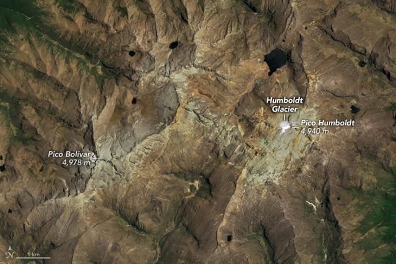
    Venezuela Humboldt Glacier 2015 Annotated
    Satellite image of Venezuela’s Humboldt Glacier captured on April 28, 2015, by the Operational Land Imager on Landsat 8.
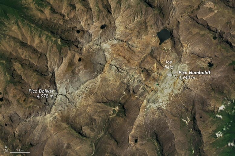
    Venezuela Humboldt Glacier 2024 Annotated
    Satellite image of Venezuela’s Humboldt Glacier captured on May 14, 2024, by the Operational Land Imager-2 on Landsat 9.

    Venezuela is the first postglacial nation in the Andes, as its last substantial patch of ice is now considered too small to flow under its own weight.

    Venezuela’s Humboldt Glacier has completely disappeared, marking a significant environmental change as it was the last glacier in a country historically covered by such ice formations. Satellite imagery from 2015 to 2024 documents this decline, showcasing the glacier’s reduction from about 0.1 square kilometers to nearly non-existent. This loss reflects a broader pattern of retreating tropical glaciers worldwide, exacerbated by rising global temperatures.

    Glacier’s Demise

    Humboldt Glacier in Venezuela has met its demise. The loss is the latest blow to our planet’s dwindling tropical glaciers, which have been shrinking and disappearing as temperatures have warmed.

    This image pair shows the change in the glacier’s ice extent between 2015 (upper) and 2024 (lower). Images were acquired with the OLI (Operational Land Imager) on Landsat 8 and OLI-2 on Landsat 9, respectively. Both images show the region toward the end of its dry season to minimize the influence of seasonal snow cover on the appearance of ice remnants.

    Humboldt Glacier has long been perched high in the Sierra Nevada de Mérida, a range in the northern extent of South America’s Andes Mountains. In 2015, scientists estimated that this glacier spanned about 0.1 square kilometers (25 acres). By 2024, the ice area had shrunk to cover approximately one-tenth of that. Although there is no universally accepted size criterion defining a glacier, scientists generally agree that an ice field of this size is stagnant, meaning it is too small to flow downslope under the pressure of its own weight. By that definition, Venezuela is now glacier-free.

    Humboldt’s Longevity and Decline

    Humboldt has been Venezuela’s last glacier since 2009, following the loss of other glaciers on nearby peaks. Despite its proximity to the equator, the glacier survived this long in part because of its altitude. Glaciers in the tropics—the region of Earth straddling the equator between latitudes of about 30°N and 30°S—exist because of the cold, snowy climate found at high elevations.

    Humboldt Glacier clung to a slope and saddle at the base of Pico Humboldt, which stands just shy of Pico Bolívar, the country’s tallest peak. Topography might have also played a role in its relative longevity. Surrounded by exceedingly steep slopes, Humboldt’s ice sat on a slightly gentler slope where snow could accumulate and compact into glacial ice during past colder conditions.

    The Wider Impact on Tropical Glaciers

    But altitude and topography have not been enough to sustain the glacier indefinitely. Evidence from satellite and aerial images, ground observations, and historical sources indicate that Humboldt Glacier has long been in decline. Spanning 3 square kilometers in 1910, it now covers about 0.01 square kilometers, making Venezuela the first postglacial nation in the Andes.

    Glaciers elsewhere in the tropics are showing a similar response to warming. The glaciers on Kilimanjaro in Tanzania and Puncak Jaya in Indonesia, for example, have become stagnant ice fields. Satellites continue to be an important tool for scientists mapping these changes and studying how the landscape and ecosystems respond.

    NASA Earth Observatory images by Michala Garrison, using Landsat data from the U.S. Geological Survey. Image interpretation and science review by Christopher Shuman, NASA/UMBC.

    Climate Science Geography Glacier NASA NASA Earth Observatory
    Share. Facebook Twitter Pinterest LinkedIn Tumblr Email

    Related Posts

    NASA Satellite Captures a Monumental Dust Wall Over the Korean Peninsula

    Melting Mysteries: The Loss of Earth’s Frozen Records

    Hydrological Anomaly: Death Valley’s Persistent Lake Explored

    Alarming Shrinkage of Norway’s Ålfotbreen Glacier – “Cannot Survive the Current Climate”

    Elevated Beauty: Peru’s Tropical Glaciers and Majestic Rainbow Mountains

    Breakup at Land Glacier: Old Sea Ice Crumbled Away off the Coast of Antarctica’s Marie Byrd Land

    Shrinking Glaciers and Growing Lakes As Temperatures Rise on the Tibetan Plateau

    Incredible Rare Peek at Patagonia in Winter

    Scientists Concerned As Denman Glacier Retreats Both Above and Below the Water Line

    Leave A Reply Cancel Reply

    • Facebook
    • Twitter
    • Pinterest
    • YouTube

    Don't Miss a Discovery

    Subscribe for the Latest in Science & Tech!

    Trending News

    Could Perseverance’s Mars Samples Hold the Secret to Ancient Life?

    Giant Fossil Discovery in Namibia Challenges Long-Held Evolutionary Theories

    Is There Anybody Out There? The Hunt for Life in Cosmic Oceans

    Paleontological Surprise: New Research Indicates That T. rex Was Much Larger Than Previously Thought

    Photosynthesis-Free: Scientists Discover Remarkable Plant That Steals Nutrients To Survive

    A Waste of Money: New Study Reveals That CBD Is Ineffective for Pain Relief

    Two Mile Long X-Ray Laser Opens New Windows Into a Mysterious State of Matter

    650 Feet High: The Megatsunami That Rocked Greenland’s East Coast

    Follow SciTechDaily
    • Facebook
    • Twitter
    • YouTube
    • Pinterest
    • Newsletter
    • RSS
    SciTech News
    • Biology News
    • Chemistry News
    • Earth News
    • Health News
    • Physics News
    • Science News
    • Space News
    • Technology News
    Recent Posts
    • Mystery Solved: Scientists Discover Unique Evolutionary Branch of Snakes
    • Unlocking the Deep Past: New Study Maps the Dawn of Animal Life
    • Scientists Uncover How Cocaine Tricks the Brain Into Feeling Good – Breakthrough Could Lead to New Substance Abuse Treatments
    • Scientists Sound the Alarm: Record Ocean Heat Puts the Great Barrier Reef in Danger
    • New Study Unravels the Mystery of COVID’s Worst Pediatric Complication
    Copyright © 1998 - 2024 SciTechDaily. All Rights Reserved.
    • Latest News
    • Trending News
    • Privacy Policy
    • Terms of Use

    Type above and press Enter to search. Press Esc to cancel.