Close Menu
    Facebook X (Twitter) Instagram
    SciTechDaily
    • Biology
    • Chemistry
    • Earth
    • Health
    • Physics
    • Science
    • Space
    • Technology
    Facebook X (Twitter) Pinterest YouTube RSS
    SciTechDaily
    Home»Earth»NASA Scientists Map Beirut Blast Damage – Devastating Explosion Rocked Port Area
    Earth

    NASA Scientists Map Beirut Blast Damage – Devastating Explosion Rocked Port Area

    By NASA Earth ObservatoryAugust 11, 2020No Comments3 Mins Read
    Facebook Twitter Pinterest Telegram LinkedIn Tumblr WhatsApp Email
    Share
    Facebook Twitter LinkedIn Pinterest Telegram Email
    Beirut Blast Damage Annotated
    July 29 – August 5, 2020. (Click image for full view.)

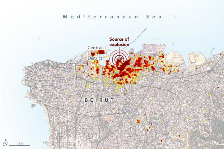
    On August 4, 2020, a devastating explosion rocked the port area around Beirut, Lebanon. After the event, scientists used satellite radar imagery to map the extent of the damage and help identify areas where people may need assistance.

    According to the Associated Press, a fire near the port ignited a large nearby store of ammonium nitrate, a highly explosive chemical often used in fertilizer. At least 135 people died, about 5,000 were wounded, and at least 300,000 people were left homeless. Losses from the blast are estimated to be at least $10 to $15 billion, according to news reports.

    The image above is a damage proxy map created by scientists affiliated with NASA’s Advanced Rapid Imaging and Analysis (ARIA) team and the Earth Observatory of Singapore (EOS). Dark red pixels represent the most severe damage, while orange and yellow areas are moderately or partially damaged. Each colored pixel represents an area of 30 square meters (about the size of a baseball diamond).

    The team at ARIA (NASA Jet Propulsion Laboratory) and EOS examined synthetic aperture radar (SAR) data collected before and after the explosion, mapping changes in the land surface and built structures. SAR instruments send pulses of microwaves toward Earth’s surface and listen for the reflections of those waves. The radar waves can penetrate cloud cover, vegetation, and the dark of night to detect changes that might not show up in visible light imagery. When Earth’ crust moves due to an earthquake, when dry land is suddenly covered by flood water, or when buildings have been damaged or toppled, the amplitude and phase of radar wave reflections changes in those areas and indicates to the satellite that something on the ground has changed.

    Though other U.S. and international agencies play more immediate roles in response to disasters, NASA plays a role in providing observations and analysis. Over the past decade, NASA has actively built its capacity to share Earth observations that can improve the prediction of, preparation for, response to, and recovery from natural and technological disasters. For instance, NASA often responds to calls for data and imagery from the International Charter for Space and Major Disasters.

    “We look at areas of likely exposed populations and fragile infrastructure, as well as areas subject to social stresses and crises. We model and map risks, while also tracking emissions, debris, infrastructure damage, and other effects from things like volcanic eruptions, fires, industrial accidents, earthquakes, and floods,” said David Green, head of NASA’s Disasters Applications team. “Our observations and analyses can help our partners increase their situational awareness of systemic risks and of real-time events, leading to better-informed decisions and early action.”

    NASA Earth Observatory image by Joshua Stevens, using modified Copernicus Sentinel data (2020) processed by ESA and analyzed by Earth Observatory of Singapore (EOS) in collaboration with NASA-JPL and Caltech, Landsat data from the U.S. Geological Survey, and data from OpenStreetMap. Story by Esprit Smith, NASA’s Earth Science News Team, and Michael Carlowicz.

    Geography NASA NASA Earth Observatory Popular
    Share. Facebook Twitter Pinterest LinkedIn Tumblr Email

    Related Posts

    Modern Oasis of Jubbah: A Long-Ago Lake Amid the Dunes

    From Russia With Questions: Distinctive Striping Pattern in Siberia Puzzles Researchers

    A Geologist’s Dream: A Short Journey to the Center of the Earth

    Spied by Satellite: Phytoplankton Factory in the Argentine Sea

    Elephant Island: The Incredible Survival Story of Ernest Shackleton and the Crew of HMS Endurance

    Robinson Crusoe Island Captured by Landsat 8 Satellite

    Huacachina: The Only Natural Oasis in South America

    NASA Picturing Earth: Astronaut Photography In Focus [Video]

    NASA Advanced Rapid Imaging Satellite Maps Blast Damage: Beirut Explosion Aftermath

    Leave A Reply Cancel Reply

    • Facebook
    • Twitter
    • Pinterest
    • YouTube

    Don't Miss a Discovery

    Subscribe for the Latest in Science & Tech!

    Trending News

    Could Perseverance’s Mars Samples Hold the Secret to Ancient Life?

    Giant Fossil Discovery in Namibia Challenges Long-Held Evolutionary Theories

    Is There Anybody Out There? The Hunt for Life in Cosmic Oceans

    Paleontological Surprise: New Research Indicates That T. rex Was Much Larger Than Previously Thought

    Photosynthesis-Free: Scientists Discover Remarkable Plant That Steals Nutrients To Survive

    A Waste of Money: New Study Reveals That CBD Is Ineffective for Pain Relief

    Two Mile Long X-Ray Laser Opens New Windows Into a Mysterious State of Matter

    650 Feet High: The Megatsunami That Rocked Greenland’s East Coast

    Follow SciTechDaily
    • Facebook
    • Twitter
    • YouTube
    • Pinterest
    • Newsletter
    • RSS
    SciTech News
    • Biology News
    • Chemistry News
    • Earth News
    • Health News
    • Physics News
    • Science News
    • Space News
    • Technology News
    Recent Posts
    • Harnessing Blue Energy: The Sustainable Power Source of Tomorrow
    • Mystery Solved: Scientists Discover Unique Evolutionary Branch of Snakes
    • Unlocking the Deep Past: New Study Maps the Dawn of Animal Life
    • Scientists Uncover How Cocaine Tricks the Brain Into Feeling Good – Breakthrough Could Lead to New Substance Abuse Treatments
    • Scientists Sound the Alarm: Record Ocean Heat Puts the Great Barrier Reef in Danger
    Copyright © 1998 - 2024 SciTechDaily. All Rights Reserved.
    • Latest News
    • Trending News
    • Privacy Policy
    • Terms of Use

    Type above and press Enter to search. Press Esc to cancel.