Close Menu
    Facebook X (Twitter) Instagram
    SciTechDaily
    • Biology
    • Chemistry
    • Earth
    • Health
    • Physics
    • Science
    • Space
    • Technology
    Facebook X (Twitter) Pinterest YouTube RSS
    SciTechDaily
    Home»Earth»NASA Advanced Rapid Imaging Satellite Maps Blast Damage: Beirut Explosion Aftermath
    Earth

    NASA Advanced Rapid Imaging Satellite Maps Blast Damage: Beirut Explosion Aftermath

    By Jet Propulsion LaboratoryAugust 8, 2020No Comments2 Mins Read
    Facebook Twitter Pinterest Telegram LinkedIn Tumblr WhatsApp Email
    Share
    Facebook Twitter LinkedIn Pinterest Telegram Email
    NASA Beirut Blast Damage
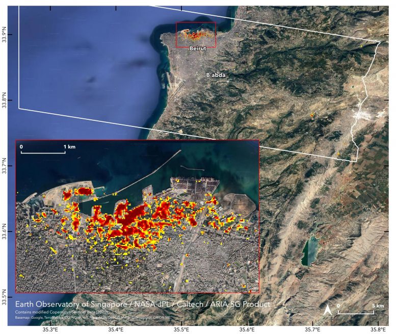
    NASA’s ARIA team, in collaboration with the Earth Observatory of Singapore, used satellite data to map the extent of likely damage following a massive explosion in Beirut. Dark red pixels represent the most severe damage. Areas in orange are moderately damaged, and areas in yellow are likely to have sustained somewhat less damage. Each colored pixel represents an area of 30 meters (33 yards). The map contains modified Copernicus Sentinel data processed by ESA (European Space Agency) and analyzed by ARIA team scientists at NASA’s Jet Propulsion Laboratory, Caltech, and Earth Observatory of Singapore. Based in Pasadena, California, Caltech manages JPL for NASA.

    Scientists are using satellite data to map ground surface changes in the aftermath of the recent explosion.

    NASA’s Advanced Rapid Imaging and Analysis (ARIA) team, in collaboration with the Earth Observatory of Singapore, used satellite-derived synthetic aperture radar data to map the likely extent of damage from a massive August 4 explosion in Beirut. Synthetic aperture radar data from space shows ground surface changes from before and after a major event like an earthquake. In this case, it is being used to show the devastating result of an explosion.

    On the map, dark red pixels — like those present at and around the Port of Beirut — represent the most severe damage. Areas in orange are moderately damaged and areas in yellow are likely to have sustained somewhat less damage. Each colored pixel represents an area of 30 meters (33 yards).

    Maps like this one can help identify badly damaged areas where people may need assistance. The explosion occurred near the city’s port. It claimed more than 150 lives and is estimated to have caused billions of dollars worth of damage.

    The map contains modified Copernicus Sentinel data processed by ESA (European Space Agency) and analyzed by ARIA team scientists at NASA JPL, Caltech, and Earth Observatory of Singapore. Located in Pasadena, California, Caltech manages JPL for NASA.

    Geography NASA NASA Earth Observatory Popular
    Share. Facebook Twitter Pinterest LinkedIn Tumblr Email

    Related Posts

    Modern Oasis of Jubbah: A Long-Ago Lake Amid the Dunes

    From Russia With Questions: Distinctive Striping Pattern in Siberia Puzzles Researchers

    A Geologist’s Dream: A Short Journey to the Center of the Earth

    Spied by Satellite: Phytoplankton Factory in the Argentine Sea

    Elephant Island: The Incredible Survival Story of Ernest Shackleton and the Crew of HMS Endurance

    Robinson Crusoe Island Captured by Landsat 8 Satellite

    Huacachina: The Only Natural Oasis in South America

    NASA Picturing Earth: Astronaut Photography In Focus [Video]

    NASA Scientists Map Beirut Blast Damage – Devastating Explosion Rocked Port Area

    Leave A Reply Cancel Reply

    • Facebook
    • Twitter
    • Pinterest
    • YouTube

    Don't Miss a Discovery

    Subscribe for the Latest in Science & Tech!

    Trending News

    Could Perseverance’s Mars Samples Hold the Secret to Ancient Life?

    Giant Fossil Discovery in Namibia Challenges Long-Held Evolutionary Theories

    Is There Anybody Out There? The Hunt for Life in Cosmic Oceans

    Paleontological Surprise: New Research Indicates That T. rex Was Much Larger Than Previously Thought

    Photosynthesis-Free: Scientists Discover Remarkable Plant That Steals Nutrients To Survive

    A Waste of Money: New Study Reveals That CBD Is Ineffective for Pain Relief

    Two Mile Long X-Ray Laser Opens New Windows Into a Mysterious State of Matter

    650 Feet High: The Megatsunami That Rocked Greenland’s East Coast

    Follow SciTechDaily
    • Facebook
    • Twitter
    • YouTube
    • Pinterest
    • Newsletter
    • RSS
    SciTech News
    • Biology News
    • Chemistry News
    • Earth News
    • Health News
    • Physics News
    • Science News
    • Space News
    • Technology News
    Recent Posts
    • Curiosity’s Wild Ride: How the Sky Crane Changed the Way NASA Explores Mars
    • Banana Apocalypse: Can Biologists Outsmart the Silent Killer?
    • Scientists Uncover Hidden Mechanism Behind Opioid Addiction – Discovery Could Revolutionize Addiction Treatment
    • How Sonic Technology Is Advancing Wind Detection on Mars
    • Harnessing Blue Energy: The Sustainable Power Source of Tomorrow
    Copyright © 1998 - 2024 SciTechDaily. All Rights Reserved.
    • Latest News
    • Trending News
    • Privacy Policy
    • Terms of Use

    Type above and press Enter to search. Press Esc to cancel.