Close Menu
    Facebook X (Twitter) Instagram
    SciTechDaily
    • Biology
    • Chemistry
    • Earth
    • Health
    • Physics
    • Science
    • Space
    • Technology
    Facebook X (Twitter) Pinterest YouTube RSS
    SciTechDaily
    Home»Earth»Meandering Mississippi River: Photo Taken by Astronaut on Space Station Shows Divergence From State Boundaries
    Earth

    Meandering Mississippi River: Photo Taken by Astronaut on Space Station Shows Divergence From State Boundaries

    By Kathryn Hansen, NASA Earth ObservatoryAugust 2, 20203 Comments3 Mins Read
    Facebook Twitter Pinterest Telegram LinkedIn Tumblr WhatsApp Email
    Share
    Facebook Twitter LinkedIn Pinterest Telegram Email
    Winding Mississippi River Annotated
    April 2, 2020. (Click image for detailed view.)

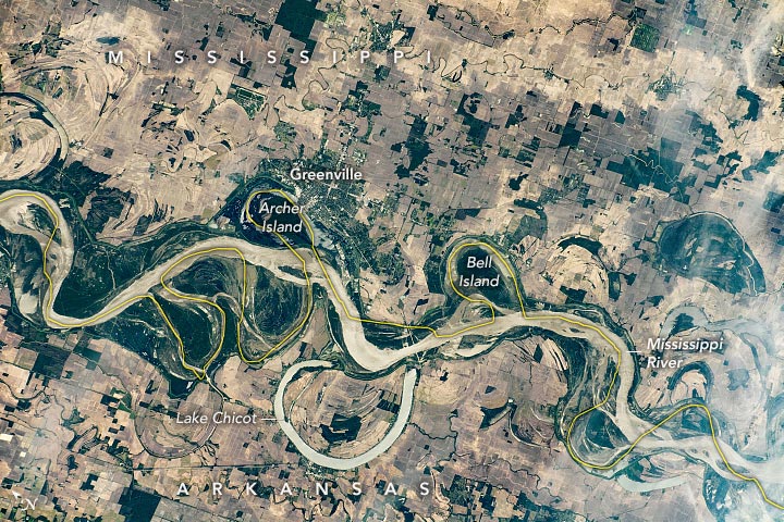
    The winding Mississippi River historically has been used to define many state lines in the United States. This photo, taken by an astronaut onboard the International Space Station (ISS), has been annotated to show the current state boundary (yellow line) between Arkansas and Mississippi. (Note that north is to the left in this image.)

    As the Mississippi River meanders over time, the channels migrate across the floodplain. Due to these changes in the position of the channel, some farms, towns, and rural lands occasionally switch to the opposite banks of the river. For instance, Archer and Bell Islands are still official parts of Arkansas, but they are now located east of the Mississippi River.

    Sunglint reflects off of the water surfaces, outlining the banks of the river and likely differentiating turbulent surface flow from slower moving water. Over thousands of years, the turbulent meandering of the river has transformed the floodplain, creating oxbow lakes and cutting new channels into the surrounding landscape. Lake Chicot is considered the largest oxbow lake in the United States, spanning 5,300 acres (2,145 hectares). In the photo, sunglint on the lake has a glossier appearance than the river, potentially due to less disturbance of the water surface.

    The Mississippi River Basin is home to many small towns and cities and a variety of agricultural activities. Nutrient-rich soil from sediment deposits throughout the floodplain supports productive cropland close to the river and its tributaries. In this photo taken during planting season, the farms are mostly distinguished by tan-brown rectangular fields, which will turn green as summer crops grow. Farming of cotton, corn, soybeans, and sweet potatoes makes up a significant portion of this area’s economic production.

    Life along the Mississippi River has its hazards, particularly flooding. Greenville and other nearby cities were almost completely submerged during the “Great Flood of 1927.” As recently as this winter, seasonal flooding took a toll on this area. To mitigate these risks, the U.S. Department of Agriculture, Army Corps of Engineers, and other agencies regularly monitor river levels, weather, and crop-growing conditions to help farmers to plan for the growing seasons and floods.

    Astronaut photograph ISS062-E-121160 was acquired on April 2, 2020, with a Nikon D5 digital camera using a 240 millimeter lens and is provided by the ISS Crew Earth Observations Facility and the Earth Science and Remote Sensing Unit, Johnson Space Center. The image was taken by a member of the Expedition 62 crew. The image has been cropped and enhanced to improve contrast, and lens artifacts have been removed. The International Space Station Program supports the laboratory as part of the ISS National Lab to help astronauts take pictures of Earth that will be of the greatest value to scientists and the public, and to make those images freely available on the Internet. Additional images taken by astronauts and cosmonauts can be viewed at the NASA/JSC Gateway to Astronaut Photography of Earth. Caption by Sara Schmidt, GeoControl Systems, and Alex Stoken, Jacobs, JETS Contract at NASA-JSC.

    Geography History NASA NASA Earth Observatory
    Share. Facebook Twitter Pinterest LinkedIn Tumblr Email

    Related Posts

    Paleozoic Plymouths: Plymouth, Massachusetts, and Plymouth, England, Share a Historical Connection Even Older Than the First Thanksgiving

    Burst of New Geochemical Evidence for Viking Travels Exactly 1,000 Years Ago

    Halloween on the Hudson: Sleepy Hollow, a Headless Horseman, and Tectonic Collisions

    Pelican Island: America’s First National Wildlife Refuge

    From Automobiles to Armstrong: Cleveland’s Urban Layout Has Evolved As Time and Technology Have Advanced

    Changing Atlanta: Martin Luther King Jr. Came of Age in One of the Fastest Growing Cities in the United States

    Elephant Island: The Incredible Survival Story of Ernest Shackleton and the Crew of HMS Endurance

    Sea Ice in Denmark Strait – Drifted More Than 1,000 Km (600 Miles) From the Arctic Ocean

    Incredible Rare Peek at Patagonia in Winter

    3 Comments

    1. Anson E. Long on August 2, 2020 3:39 pm

      The river doesn’t obey human laws, of course.

      Reply
    2. Eugene Wall on August 3, 2020 8:44 am

      The river hasn’t meandered since the 1940’s. The Army Corps Mat Sinking Unit armors the banks with concrete mats to prevent “meandering”.

      Yes the state boundaries are wonky but it’s not from anything happening now.

      Reply
    3. CeeVee on August 4, 2020 6:10 pm

      What? you mean the Mississippi River does not respect state boundaries? Time to arrest it? Mother Natures answer: Try me, remember I bat in the last inning.

      Reply
    Leave A Reply Cancel Reply

    • Facebook
    • Twitter
    • Pinterest
    • YouTube

    Don't Miss a Discovery

    Subscribe for the Latest in Science & Tech!

    Trending News

    Could Perseverance’s Mars Samples Hold the Secret to Ancient Life?

    Giant Fossil Discovery in Namibia Challenges Long-Held Evolutionary Theories

    Is There Anybody Out There? The Hunt for Life in Cosmic Oceans

    Paleontological Surprise: New Research Indicates That T. rex Was Much Larger Than Previously Thought

    Photosynthesis-Free: Scientists Discover Remarkable Plant That Steals Nutrients To Survive

    A Waste of Money: New Study Reveals That CBD Is Ineffective for Pain Relief

    Two Mile Long X-Ray Laser Opens New Windows Into a Mysterious State of Matter

    650 Feet High: The Megatsunami That Rocked Greenland’s East Coast

    Follow SciTechDaily
    • Facebook
    • Twitter
    • YouTube
    • Pinterest
    • Newsletter
    • RSS
    SciTech News
    • Biology News
    • Chemistry News
    • Earth News
    • Health News
    • Physics News
    • Science News
    • Space News
    • Technology News
    Recent Posts
    • Curiosity’s Wild Ride: How the Sky Crane Changed the Way NASA Explores Mars
    • Banana Apocalypse: Can Biologists Outsmart the Silent Killer?
    • Scientists Uncover Hidden Mechanism Behind Opioid Addiction – Discovery Could Revolutionize Addiction Treatment
    • How Sonic Technology Is Advancing Wind Detection on Mars
    • Harnessing Blue Energy: The Sustainable Power Source of Tomorrow
    Copyright © 1998 - 2024 SciTechDaily. All Rights Reserved.
    • Latest News
    • Trending News
    • Privacy Policy
    • Terms of Use

    Type above and press Enter to search. Press Esc to cancel.