Preliminary reports suggest it is the fifth-strongest storm ever to make landfall in the continental U.S.
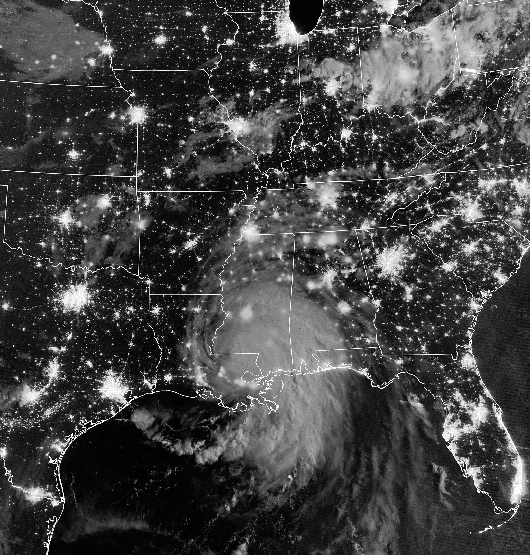
Exactly 16 years after Katrina made landfall, another major hurricane blew into southern Louisiana. Around noon on August 29, 2021, Hurricane Ida came ashore at Port Fourchon with sustained winds of 150 miles (240 kilometers) per hour and a central pressure of 930 millibars. Preliminary reports suggest it is the fifth strongest hurricane (based on wind speed) ever to make landfall in the continental U.S.
At 2:50 a.m. Central Daylight Time on August 30, the Visible Infrared Imaging Radiometer Suite (VIIRS) on the Suomi NPP satellite acquired a nighttime view (above) of Hurricane Ida. On the morning of August 29, the NOAA GOES-16 satellite acquired data for an animation of the menacing eyewall approaching the coast.
In the last 24 hours before landfall, the storm’s central pressure dropped from 985 millibars to 929, and winds intensified rapidly from 85 to 150 miles per hour. According to the National Hurricane Center, a storm has undergone “rapid intensification” when winds increase by at least 35 miles per hour within 24 hours. The intensification was partly fueled by the hot summer surface waters of the Gulf of Mexico, which were about 30–31° Celsius (86–88° Fahrenheit).
August 27 – 30, 2021
The animation above shows the evolution of Ida’s wind field between August 27–30, 2021. The strongest winds appear bright yellow to white; more moderate winds (still gale-force) are shades of orange and bright purple. Atmospheric data have been run through the Goddard Earth Observing System Model-5 (GEOS-5), a data assimilation model that scientists at NASA use to analyze global weather phenomena. The GEOS model ingests wind data from more than 30 sources, including ships, buoys, radiosondes, dropsondes, aircraft, and satellites. The model output is spaced out on a 0.25 to 0.3 degree grid, so it does not necessarily capture peak gusts and extremes as measured by individual instruments on the surface.
“For me, the most compelling aspect of Ida was its rapid intensification up to landfall,” said Scott Braun, a scientist who specializes in hurricanes at NASA’s Goddard Space Flight Center. “The storm was very similar to Hurricane Opal and Hurricane Katrina in that they underwent rapid intensification over a region, or eddy, of deep warm water known as the Gulf Loop Current. In addition to providing warm water for fuel, such eddies impede the mixing of colder water to the surface. Such cooling would typically lead to storm weakening, or at least an end to strengthening. Both Opal and Katrina weakened before landfall, mitigating the impacts of the storms to some extent, even though they were obviously still bad. In Ida, near-coast weakening did not really occur.”
The hurricane pushed a wall of water—a storm surge—onto the coast of Louisiana and Mississippi. Weather stations and media reports noted surges ranging from 3 to 9 feet (1 to 3 meters) in places like Grande Isle, Shell Beach, Lafitte, Barataria, Port Fourchon, and Bay Waveland. Port Fourchon is a major commercial and industrial hub for the United States, particularly for oil and gas.
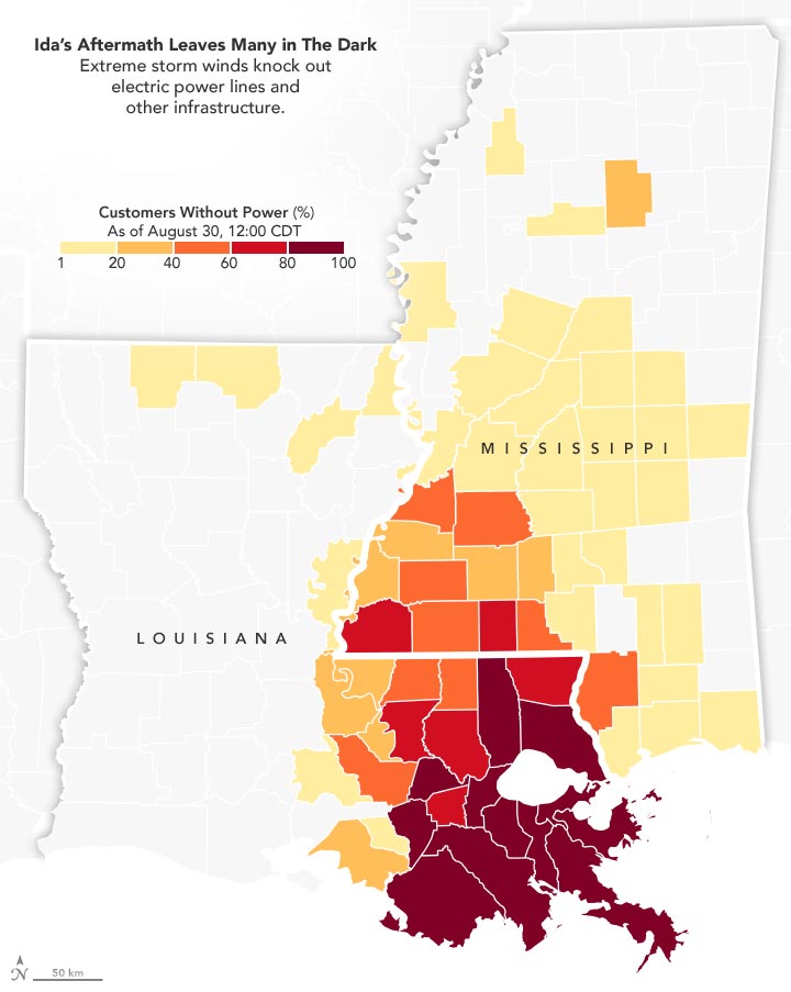
The storm lingered over southern Louisiana for most of August 29, dropping flood-provoking rainfall before moving north and east into Mississippi and Alabama on August 30. The slow pace of the storm may have amplified the serious damage to electric power and drinking water infrastructure, while delaying the start of cleanup. More than 1 million customers (businesses, households) in Louisiana had reportedly lost power by midday on August 30. Another 100,000 customers lost electricity in Mississippi and 12,000 in Alabama. The map above shows the distribution of power outages as compiled by PowerOutage.US from publicly accessible data sources.
“I was interested in Ida’s translational speed after landfall,” said Hui Su, who studies hurricanes at NASA’s Jet Propulsion Laboratory. “There have been studies that have talked about how global warming causes the slowing down of tropical cyclones, which can contribute to greater flooding and inundation damages. (For example, hurricanes Harvey and Dorian.) There are still debates because of the quality of historical data, but climate model simulations show that the translational speed of hurricanes would decrease with global warming.”
NASA Earth Observatory images and video by Joshua Stevens, using VIIRS day-night band data from the Suomi National Polar-orbiting Partnership, GEOS-5 data from the Global Modeling and Assimilation Office at NASA GSFC, and power outage data courtesy of PowerOutage.us.